
 Canadian Dollars


Guaranteed Fitment
Always the correct part


have questions?
Always the correct part
We know our products
Fast & Reliable


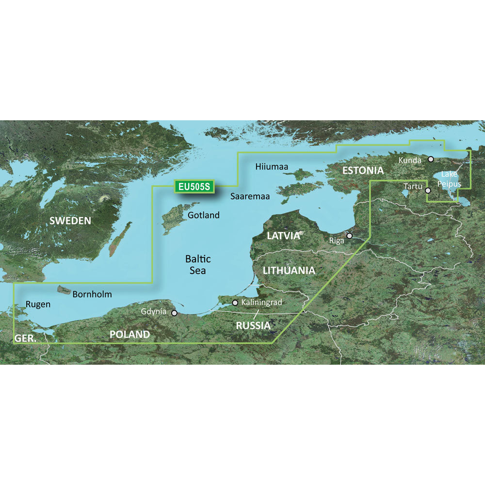
BlueChart® g2 HD - HXEU065R - Baltic Sea East Coast - microSD/SD
Coverage:
Coverage of the coasts of the Estonia, Latvia, Lithuania, Russia, and Poland from Narva-Joesuu, Est. to Rugen, Ger. Includes Gotland, Bornholm, Gulf of Riga, Kaliningrad, Rus., and the Polish cities of Gdansk, Gdynia, and Szczecin.
Unparalleled Coastal Chart Coverage
BlueChart g3 coastal charts provide industry-leading coverage, clarity and detail with integrated Garmin and Navionics data. Also included is Auto Guidance1 technology, which uses your desired depth and overhead clearance to calculate routes and provide a suggested path to follow overlaid onto your chart. NOAA raster cartography is also available as a free downloadable feature via the ActiveCaptain app. It gives your chartplotter paper chartlike views of NOAA-surveyed areas in which individual points of interest are labeled with corresponding longitude and latitude information. Worldwide coverage is available by regions as accessory cards or via download; each region is sold separately.
Auto Guidance Technology
The Auto Guidance feature¹ calculates a suggested route using your desired depth and overhead clearance.
Depth Range Shading
This feature displays high-resolution Depth Range Shading for up to 10 depth ranges so you can view your designated target depth.
Detailed Contours
BlueChart g3 charts feature 1 contours that provide a more accurate depiction of bottom structure for improved fishing charts and enhanced detail in swamps, canals and port plans.
Shallow Water Shading
To aid in navigation, Shallow Water Shading allows map shading at a user-defined depth to give a clear picture of shallow waters to avoid.
NOAA Raster Cartography
This feature gives your chartplotter paper chartlike views of NOAA-surveyed areas in which points of interest are labeled with corresponding longitude and latitude information.
¹Auto Guidance is for planning purposes only and does not replace safe navigation practices. Auto Guidance is not included in preloaded BlueChart g3 for ECHOMAP Plus series chartplotters
 WARNING: This product can expose you to chemicals which are known to the State of California to cause cancer, birth defects or other reproductive harm. For more information go to .
| Type: | |
|---|---|
| Vendor: |
Garmin |
| Weight: |
0.1 lb |
| Product Manual: |
All returns must be authorized. Items returned prior to authorization will not be accepted. For international customers where applicable, customers must ship any returns to us freight and duty prepaid. Return freight charges for internationsl shippments will be the responsibility of the customer.
Defective new equipment may be returned for warrantyrepair/exchange to us within (5) days of the shipment receipt date. After five (5) days, returns will be handled by direct contact and in accordance with the warranty terms of the item's manufacturer. Items that have malfunctioned due to mishandling, electrical overload, etc., will be subject to repair charge.
Non defective new equipment will be authorized for return within five (5) days of the shipment receipt date if the equipment is still in new, re-sellable condition with the original manual(s), accessories, packing material and carton. We reserve the right to reject returnsin which there is no original packaging, missing accessories, damage or visible signs of usage of the item. A restocking fee of up to 25% of purchase price may apply. Special orders and dangerous goods are non-returnable.
(Do not write anytingon the manufacturer's original package or use as a shipping carton. Include all accessories, manuals and warranties.)
Please, include a copy of the packing list or invoice with a reason for the return. Your return authorization number is valid for thirty (30) days.
We can ship to both US and Canada. Note that there are restrictions on some products, and some products cannot be shipped to international destinations.
When you place an order, we will charge a flat rate shipping for your items.
Please also note that the shipping rates for many items we sell are weight-based. The weight of any such item can be found on its detail page. To reflect the policies of the shipping companies we use, all weights will be rounded up to the next full pound.
Not Applicable
| Condition: | NA |
Defective new equipment may be returned for warrantyrepair/exchange to us within (5) days of the shipment receipt date. After five (5) days, returns will be handled by direct contact and in accordance with the warranty terms of the item's manufacturer. Items that have malfunctioned due to mishandling, electrical overload, etc., will be subject to repair charge.
Non defective new equipment will be authorized for return within five (5) days of the shipment receipt date if the equipment is still in new, re-sellable condition with the original manual(s), accessories, packing material and carton. We reserve the right to reject returnsin which there is no original packaging, missing accessories, damage or visible signs of usage of the item. A restocking fee of up to 25% of purchase price may apply. Special orders and dangerous goods are non-returnable.
(Do not write anytingon the manufacturer's original package or use as a shipping carton. Include all accessories, manuals and warranties.)
Please, include a copy of the packing list or invoice with a reason for the return. Your return authorization number is valid for thirty (30) days.


