
 Canadian Dollars


have questions?
Always the correct part
We know our products
Fast & Reliable


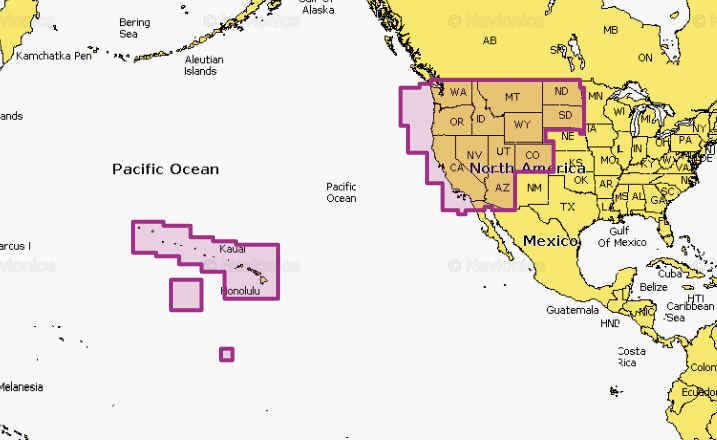
Get the worlds Number one choice in marine mapping: with the best, most up-to-date Navionics+ cartography on your compatible chart plotter. For offshore or inland waters, this all-in-one solution offers detail-rich integrated mapping of coastal waters, lakes, rivers and more. Get SonarChart 1 Feet HD bathymetry maps, advanced features such as dock-to-dock route guidance technology , live mapping and Plotter Sync to provide wireless access to daily updates. The Navionics Chart Installer software also ensures the freshest chart data every time out. Navionics dock-to-dock route guidance solutions give you a suggested path to follow through channels, inlets, marina entrances and more. Multiple shading options aid in shallow water navigation and make it easy to highlight a target depth range for the best fishing spots. Detailed coverage of the lakes, rivers and coasts of Arizona, California, Colorado, Idaho, Montana, Nevada, North Dakota, Oregon, South Dakota, Utah, Washington, and Wyoming, Hawaii, and the Johnston and Palmyra Atolls.
NAUS008R U.S. West - MicroSD Card
Detailed coverage of the lakes, rivers, and coasts of Arizona, California, Colorado, Idaho, Montana, Nevada, North Dakota, Oregon, South Dakota, Utah, Washington, Wyoming, Hawaii, and the Johnston and Palmyra Atolls.
Get the worlds No. 1 choice in marine mapping with the best, most up-to-date Navionics®+ cartography on your compatible chartplotter. For offshore or inland waters, this all-in-one solution offers detail-rich integrated mapping of coastal waters, lakes, rivers, and more. Get SonarChart 1 (0.5 meters) HD bathymetry maps, advanced features such as dock-to-dock route guidance technology (depending on chartplotter model), live mapping, and Plotter Sync to provide wireless access to daily updates. The Navionics® Chart Installer software also ensures the freshest chart data every time out. Navionics route guidance solutions give you a suggested dock-to-dock path to follow through channels, inlets, marina entrances, and more. (Route guidance is for planning purposes only and does not replace safe navigation operations.) Multiple shading options aid in shallow water navigation and make it easy to highlight a target depth range for the best fishing spots.
Features:
**NOT FOR USE IN GARMIN CHARTPLOTTERS**
Navionics Plus NAUS008R U.S. West microSD
Model: 010-C1371-30Detailed coverage of the lakes, rivers and coasts of Arizona, California, Colorado, Idaho, Montana, Nevada, North Dakota, Oregon, South Dakota, Utah, Washington, and Wyoming, Hawaii, and the Johnston and Palmyra Atolls.
Get the worlds No. 1 choice in marine mapping (based on 2020 reported sales) with the best, most up-to-date Navionics®+ cartography on your compatible chartplotter. For offshore or inland waters, this all-in-one solution offers detail-rich integrated mapping of coastal waters, lakes, rivers and more. Get SonarChart 1 (0.5 meter) HD bathymetry maps, advanced features such as dock-to-dock route guidance technology (depending on chartplotter model), live mapping and Plotter Sync to provide wireless access to daily updates. The Navionics® Chart Installer software also ensures the freshest chart data every time out. Navionics route guidance solutions give you a suggested dock-to-dock path to follow through channels, inlets, marina entrances and more. (Route guidance is for planning purposes only and does not replace safe navigation operations.) Multiple shading options aid in shallow water navigation and make it easy to highlight a target depth range for the best fishing spots.
"| Type: | |
|---|---|
| Vendor: |
Navionics |
All returns must be authorized. Items returned prior to authorization will not be accepted. For international customers where applicable, customers must ship any returns to us freight and duty prepaid. Return freight charges for internationsl shippments will be the responsibility of the customer.
Defective new equipment may be returned for warrantyrepair/exchange to us within (5) days of the shipment receipt date. After five (5) days, returns will be handled by direct contact and in accordance with the warranty terms of the item's manufacturer. Items that have malfunctioned due to mishandling, electrical overload, etc., will be subject to repair charge.
Non defective new equipment will be authorized for return within five (5) days of the shipment receipt date if the equipment is still in new, re-sellable condition with the original manual(s), accessories, packing material and carton. We reserve the right to reject returnsin which there is no original packaging, missing accessories, damage or visible signs of usage of the item. A restocking fee of up to 25% of purchase price may apply. Special orders and dangerous goods are non-returnable.
(Do not write anytingon the manufacturer's original package or use as a shipping carton. Include all accessories, manuals and warranties.)
Please, include a copy of the packing list or invoice with a reason for the return. Your return authorization number is valid for thirty (30) days.
We can ship to both US and Canada. Note that there are restrictions on some products, and some products cannot be shipped to international destinations.
When you place an order, we will charge a flat rate shipping for your items.
Please also note that the shipping rates for many items we sell are weight-based. The weight of any such item can be found on its detail page. To reflect the policies of the shipping companies we use, all weights will be rounded up to the next full pound.
Not Applicable
| Condition: | NA |
Defective new equipment may be returned for warrantyrepair/exchange to us within (5) days of the shipment receipt date. After five (5) days, returns will be handled by direct contact and in accordance with the warranty terms of the item's manufacturer. Items that have malfunctioned due to mishandling, electrical overload, etc., will be subject to repair charge.
Non defective new equipment will be authorized for return within five (5) days of the shipment receipt date if the equipment is still in new, re-sellable condition with the original manual(s), accessories, packing material and carton. We reserve the right to reject returnsin which there is no original packaging, missing accessories, damage or visible signs of usage of the item. A restocking fee of up to 25% of purchase price may apply. Special orders and dangerous goods are non-returnable.
(Do not write anytingon the manufacturer's original package or use as a shipping carton. Include all accessories, manuals and warranties.)
Please, include a copy of the packing list or invoice with a reason for the return. Your return authorization number is valid for thirty (30) days.


