US Dollar


have questions?
Always the correct part
We know our products
Fast & Reliable


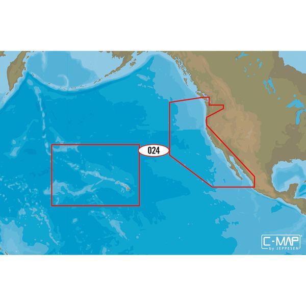
C-MAP M-NA-D024 4D microSD
USA West Coast and Hawaii
Model: M-NA-D024-MSDominate the water with C-MAPs full vector charts, harbor and approach details, tide and current tools, and more.
Full-Feature Vector Charts give you tools like tidal streams, detailed roads, and accurate marina plans, giving you the utmost situational awareness in your covered area.
High-Definition Aerial Photography will ensure you get the best view of where you are and where youre going even in sub-optimal conditions.
Expandability is built-in to these cards via Value Added Data Segments (sold separately) so that when you need that extra local detail, adding it to the charts you already use is hassle-free.
One Free Year of daily updates means you will have the most accurate, up-to-date information available, keeping you and your crew safe out on the water.
Coverage:
The Pacific Coast of the United States; Baja California and Mexico down to Puerto Vallarta
Includes: All of the coasts of California, Oregon and Washington; The Columbia River; The Sacramento River; The Willamette River; Snake River; San Joaquin River; Puget Sound; The San Juan Islands up to Point Roberts
Additional Cartography: The Hawaiian Islands out to Midway and Johnston Atoll
| Type: | |
|---|---|
| Vendor: |
C-MAP |
| Weight: |
0.18 lb |
All returns must be authorized. Items returned prior to authorization will not be accepted. For international customers where applicable, customers must ship any returns to us freight and duty prepaid. Return freight charges for internationsl shippments will be the responsibility of the customer.
Defective new equipment may be returned for warrantyrepair/exchange to us within (5) days of the shipment receipt date. After five (5) days, returns will be handled by direct contact and in accordance with the warranty terms of the item's manufacturer. Items that have malfunctioned due to mishandling, electrical overload, etc., will be subject to repair charge.
Non defective new equipment will be authorized for return within five (5) days of the shipment receipt date if the equipment is still in new, re-sellable condition with the original manual(s), accessories, packing material and carton. We reserve the right to reject returnsin which there is no original packaging, missing accessories, damage or visible signs of usage of the item. A restocking fee of up to 25% of purchase price may apply. Special orders and dangerous goods are non-returnable.
(Do not write anytingon the manufacturer's original package or use as a shipping carton. Include all accessories, manuals and warranties.)
Please, include a copy of the packing list or invoice with a reason for the return. Your return authorization number is valid for thirty (30) days.
We can ship to both US and Canada. Note that there are restrictions on some products, and some products cannot be shipped to international destinations.
When you place an order, we will charge a flat rate shipping for your items.
Please also note that the shipping rates for many items we sell are weight-based. The weight of any such item can be found on its detail page. To reflect the policies of the shipping companies we use, all weights will be rounded up to the next full pound.
Not Applicable
| Condition: | NA |
Defective new equipment may be returned for warrantyrepair/exchange to us within (5) days of the shipment receipt date. After five (5) days, returns will be handled by direct contact and in accordance with the warranty terms of the item's manufacturer. Items that have malfunctioned due to mishandling, electrical overload, etc., will be subject to repair charge.
Non defective new equipment will be authorized for return within five (5) days of the shipment receipt date if the equipment is still in new, re-sellable condition with the original manual(s), accessories, packing material and carton. We reserve the right to reject returnsin which there is no original packaging, missing accessories, damage or visible signs of usage of the item. A restocking fee of up to 25% of purchase price may apply. Special orders and dangerous goods are non-returnable.
(Do not write anytingon the manufacturer's original package or use as a shipping carton. Include all accessories, manuals and warranties.)
Please, include a copy of the packing list or invoice with a reason for the return. Your return authorization number is valid for thirty (30) days.